![](/images/other/stat-length.png)
![Trail Walking La Bresse - Lacs de la Lande et de Blanchemer par le Grand Artimont - Photo](https://media.geolcdn.com/t/1900/400/ext.pjpeg?maxdim=2&url=https%3A%2F%2Fservices.sitytrail.com%2FGeolivesWS%2FDownloadMedia.ashx%3FTrailID%3D452923%26Media%3Dfix__20150720164619.jpg)
Lacs de la Lande et de Blanchemer par le Grand Artimont
ScarniereLaurent
User
![Length](/images/other/stat-length.png)
![Max alt](https://static1.geolcdn.com/siteimages/upload/files/1508320355ic_sort_altitude_max_24dp.png)
![Uphill gradient](https://static1.geolcdn.com/siteimages/upload/files/1508320355ic_sort_den_pos_24dp.png)
![Km-Effort](/images/other/stat-length.png)
![Min alt](https://static1.geolcdn.com/siteimages/upload/files/1508320355ic_sort_altitude_min_24dp.png)
![Downhill gradient](https://static1.geolcdn.com/siteimages/upload/files/1508320355ic_sort_den_neg_24dp.png)
![Boucle](https://static1.geolcdn.com/siteimages/upload/files/16400158638029165_repeat_loop_refresh_sync_direction_icon.png)
![Walking](https://static1.geolcdn.com/sitytour/trail-icons/101.png)
3h28
Difficulty : Medium
![Scan this QR Code to open this trail in the SityTrail application](https://capi.geolives.com/qq0zvz2zws4bq2lad0pu/sitytour/trails/452923/qr.png?size=200)
FREE GPS app for hiking
About
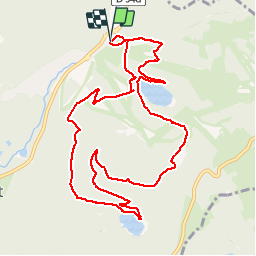
Trail Walking of 11.7 km to be discovered at Grand Est, Vosges, La Bresse. This trail is proposed by ScarniereLaurent.
Description
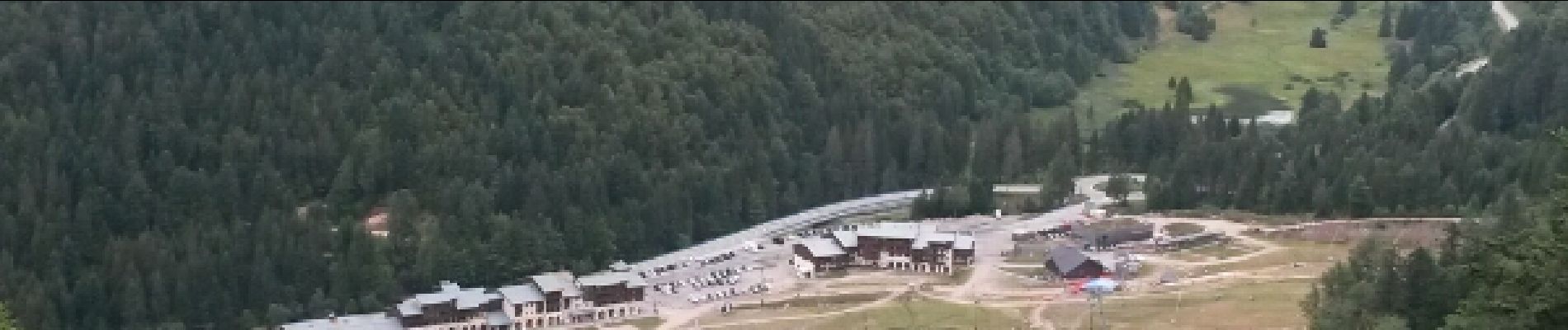
Au départ du parking de la station les Grandes Feignes (station La Bresse-Hohneck), montée à travers bois par la piste jusqu'au Lac de La Lande et son barrage. La suite se fait à travers un petit chemin de randonnée sous bois et permet de rejoindre des sentiers de randonnées qui contournent le Grand Artimont et permettent de rejoindre le lac de Blanchemer. Le retour se fait également par un sentier forestier de bonne dénivellation avant de redescendre sur la station du depart. Bonne randonnée!
Positioning
Comments
Trails nearby
![Trail Walking La Bresse - 2023-04-16 Marche Abri Lac de Blanchemer vers Lac de Lispach - Photo](https://media.geolcdn.com/t/375/260/20b642e6-a3a8-4790-bc8e-b2ad298c0408.jpg&format=jpg&maxdim=2)
![Walking Walking](https://static1.geolcdn.com/sitytour/trail-icons/101.png)
Walking
![](/images/other/stat-length.png)
![](https://static1.geolcdn.com/siteimages/upload/files/16400158638029165_repeat_loop_refresh_sync_direction_icon.png)
![Trail Walking La Bresse - 2023-04-15 Marche Abri Collet de Etang vers Abri Lac de Blanchemer - Photo](https://media.geolcdn.com/t/375/260/f5705708-8e73-435e-a1e8-28d1d0c03215.jpg&format=jpg&maxdim=2)
![Walking Walking](https://static1.geolcdn.com/sitytour/trail-icons/101.png)
Walking
![](/images/other/stat-length.png)
![](https://static1.geolcdn.com/siteimages/upload/files/16400158638029165_repeat_loop_refresh_sync_direction_icon.png)
![Trail Walking Le Valtin - Les Rochers des Hirschsteine - Lac Vert - Photo](https://media.geolcdn.com/t/375/260/4177d9e5-d8bc-4dac-ac45-c42f01ca30d3.jpg&format=jpg&maxdim=2)
![Walking Walking](https://static1.geolcdn.com/sitytour/trail-icons/101.png)
Walking
![](/images/other/stat-length.png)
![](https://static1.geolcdn.com/siteimages/upload/files/16400158638029165_repeat_loop_refresh_sync_direction_icon.png)
![Trail Walking La Bresse - Kastelberg des pierres, des lacs, des panoramas magnifiques - Photo](https://media.geolcdn.com/t/375/260/cada329c-fae7-4d3f-815e-38ed5d6ce361.jpg&format=jpg&maxdim=2)
![Walking Walking](https://static1.geolcdn.com/sitytour/trail-icons/101.png)
Walking
![](/images/other/stat-length.png)
![](https://static1.geolcdn.com/siteimages/upload/files/16400158638029165_repeat_loop_refresh_sync_direction_icon.png)
![Trail Walking Le Valtin - Col de la Schlucht - Photo](https://media.geolcdn.com/t/375/260/5b598871-c43c-4378-92fe-f06bddb4af29.jpg&format=jpg&maxdim=2)
![Walking Walking](https://static1.geolcdn.com/sitytour/trail-icons/101.png)
Walking
![](/images/other/stat-length.png)
![](https://static1.geolcdn.com/siteimages/upload/files/16400158638029165_repeat_loop_refresh_sync_direction_icon.png)
![Trail Walking Le Valtin - Le Sentier des Roches - Photo](https://media.geolcdn.com/t/375/260/f2737479-0e9e-43ec-9b66-c9706dc8ef91.jpg&format=jpg&maxdim=2)
![Walking Walking](https://static1.geolcdn.com/sitytour/trail-icons/101.png)
Walking
![](/images/other/stat-length.png)
![](https://static1.geolcdn.com/siteimages/upload/files/16400158638029165_repeat_loop_refresh_sync_direction_icon.png)
![Trail Walking La Bresse - Lac de Lispach et sentier Dielaine - Photo](https://media.geolcdn.com/t/375/260/b54731ea-6209-4cff-b7c0-af5225a4f3ae.jpg&format=jpg&maxdim=2)
![Walking Walking](https://static1.geolcdn.com/sitytour/trail-icons/101.png)
Walking
![](/images/other/stat-length.png)
![](https://static1.geolcdn.com/siteimages/upload/files/16400158638029165_repeat_loop_refresh_sync_direction_icon.png)
![Trail Walking Stosswihr - Tour du belvedere avec le passage sur les crêtes - Photo](https://media.geolcdn.com/t/375/260/5b3c85c1-2643-45e9-9769-80e100e05dda.jpg&format=jpg&maxdim=2)
![Walking Walking](https://static1.geolcdn.com/sitytour/trail-icons/101.png)
Walking
![](/images/other/stat-length.png)
![](https://static1.geolcdn.com/siteimages/upload/files/16400158638029165_repeat_loop_refresh_sync_direction_icon.png)
![Walking Walking](https://static1.geolcdn.com/sitytour/trail-icons/101.png)
Walking
![](/images/other/stat-length.png)
![](https://static1.geolcdn.com/siteimages/upload/files/16400158638029165_repeat_loop_refresh_sync_direction_icon.png)